4) See below for what happens if your maps overlap even slightly and you try to load them into your RM300..
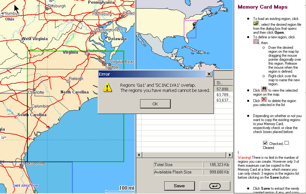
Map areas are NOT ALLOWED TO OVERLAP. And.. Magellan does not tell you that two adjacent regions overlap UNTIL you try to load them. In practical terms, this means that you must always leave a small gap between the new map region and any other map regions you have already selected. This because (for me at least!), zooming in and out to see how close you were to the adjacent region while keeping the left mouse button pressed to hold the "map select box" proved to be too much to handle with one mouse and two hands. MAGELLAN DESIGNERS need to fix this!!! Thus maps in the RM300 will (must) always have a small gap between the 240meg uploaded sections. I made the gap as small as I could using a mouse and it turned out to be maybe 5 miles wide in the final loads. Of course, the RM300 does have a basemap and it will ride off the loaded 80meg region and (hopefully) onto your adjacent 80meg region IF that region is one of the three you loaded in a group of 3 regions (3x80megs). Note that when operating the RM300, once you ride off the "3 region map group" that you have selected, you must MANUALLY select the adjacent (if any) region group that you loaded. Otherwise you will just see the basemap from that point onward. Also, make sure your desired destinations are not near one of your "map gaps" between the 80 meg regions as you MUST leave a small gap between 80 meg regions.
The good news is: Once you get your maps loaded, you likely will not have to mess much with them again for a long time!
We have not before seen a GPS system that would hold large map areas which was so tedious and complex to load maps into. Hopefully, Magellan will correct this (we think) serious engineering defect soon. When they do, we know their customers will benefit and they will be able to sell lots more of these otherwise fine units.
2) A lot of time is involved in loading maps into the SD card map memory of the RM300. It took around 9 hours of clock time to register, select, build and load the 1GByte of memory. Human time was about 1 period of 30 minutes reading the manual, registration of GPS, attempt registration of SD card, learn that it is "unauthorized", find in the manual that "unauthorized" probably means not formatted, Format the SD card, and then 5 periods of map selection 10 minutes each with an "up to" 120 minute interval of map converting and loading between each map selection time. Compare this with the Garmin c320 which also uses an SD card where registration was about 5 minutes, map selection was about 5 minutes and unattended map download was about 2 hours. Being able to overlap multiple map sections and then load the entire 1GByte SD card at once is what is needed. Computer used was Dell Inspiron 8600 with 1.4Ghz-M processor and 512megs of memory.
3) The Magellan RoadMate Manager software has some operational problems. When we were using it to load maps, if we tried to use other applications while we waited, we had several complete system lockups on Windows XP professional with all latest mods. We suggest letting RoadMate Manager run all alone on a computer when you are building and downloading maps to your RM300. Hopefully Magellan engineers will sort out this problem in future releases.
4) Our RM300 failed when Jack accidently plugged the power cable into the earphone jack. Hopefully this will not happen to many other people, but the fact that you can insert the power cable into the earphone jack (or any other connection) and damage the unit (in our opinion) is a design feature worth considering.
5) Uniquely, the RM300 (by Magellan policy) will not allow you to load European road maps into a USA version RM300 and vice versa. There is no ability to buy a European SD card and plug it into a USA RM300. We consider this policy to be not in the consumer's interest, and especially for those who travel to foreign countries.
SUMMARY
Map Loading in the RoadMate 300 is so tedious and the resulting maps sufficiently difficult to use that we judge the Map Management software NOT ACCEPTABLE FOR ORDINARY PEOPLE TO USE. Having to leave small gaps between loaded 80meg areas in the maps is not acceptable. Having to manually switch between map sections as you drive from one map section to another is not acceptable. The time and hassle needed to load the maps is not acceptable. Having the computer lockup when you try and do something else while maps are loading is not acceptable. This is the only GPS car navigator unit we have reviewed where the maps were so difficult to install and use that we had to rate the system not acceptable. We sincerely hope that Magellan engineers will correct this problem right away.
Note that the RoadMate 500 and RoadMate 700 DO NOT have these problems.
Joe Mehaffey