GPS Product Review
by Joe Mehaffey
Release 10 updated, 15 November 2005
 .
.
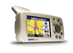
Quest GPS unit
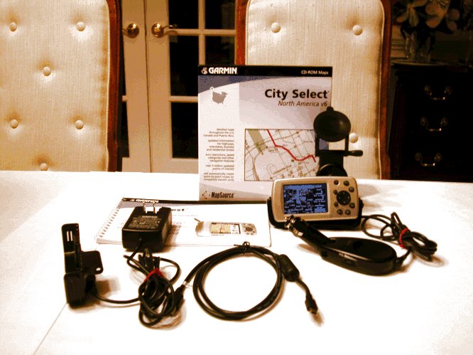
Quest Kit
Daytime Map
Colors
.
Quest GPS unit
Quest Kit
Daytime Map
Colors
Quest Features
These sleek
units have the GPS
antenna integral within
the unit and is designed to fit on top of
your dash and provide you with visual and audio directions for
navigating your car on unfamiliar streets and roads.
Unfortunately (for the kids),
Garmin did not
choose to put any games in this model. The Quest continues
Garmin's marketing plan of "Market Specialization" which means to
position various models for specific functionality and leave out
specific features of interest to a specific group of users. For
example, our "ideal" general purpose GPS receiver would have a
color screen, CF or SD card memory, full marine and hiking
feature set, full car navigation capabilities and a rechargable
battery pack with external power capability. Lets see how
the Quest fits these requirements.
The
Quest's screen is a high brightness
TFT daylight viewable-without-backlight screen such as is available on
the G60C and G76C. However, the Quest uses a different filter
from the
G60C and G76C which (I think) makes the display much "less bright"
without
the backlight turned on as compared with the G60C and G76C. (Joe
will confirm this when he returns home.) TFT screens do not offer
a contrast control. Quest has no marine feature set (at this
time) and all but the most basic
hiking features are missing. Quest does have a rechargable
battery pack which will
run the unit with backlight( on for short periods in normal
driving/routing) for 6 hours or up to 20 hours (backlight
off) and it does have the
capability of being run from external 12volt power (furnished voltage
regulator/speaker cable
required). Note that the Quest internal battery is charged
anytime
the unit is running on external 12volt power from either the 12volt
speaker cable OR the 12volt external power supply. It
CANNOT be
recharged by a USB connection as not enough energy is available from
that source to either power the unit or recharge the
battery. The Lithium Ion battery is sealed into the
package and is not normally user serviceable.
The features of the
miniaturized Quest make it a (fairly) direct competitor to the Magellan
RoadMate and to the StreetPilot 2610. Our Magellan RoadMate
review can be found HERE.
And the StreetPilot 2610 review can be found HERE.
As stated before, Quest is NOT a direct competitor to the full featured
hiking and marine oriented handheld units.
Street priced at
about $525 (Can be bought for up to $695), (Check
Latest Prices Here.)
the Quest is one of
the
lowest priced Automatic Car Navigator units available. And
certainly, it is about the smallest.
What about map loading and Map
Memory?
Quest uses a USB data interface
for
map loading and data input/output. It has no standard NMEA
input/output capability but it can send position data to MapSource map
products so you can track on your external USB equipped laptop if you
want. The 115 megabyte map memory will hold
approximately the states of Florida, Georgia and South Carolina with a
little of Tennessee thrown in. In Europe, we find that the
115Mbyte Quest will
hold about half the UK or a bit less than half of France. You can
put part USA, part UK, and part France maps into the unit at the same
time if you wish. Quest comes with a routable basemap for your
region
(like VISTA/LEGEND COLOR (LC/VC) and StreetPilot models. Also
packaged in the Quest Kit is the CitySelect Map system for the USA and
Canada (or other region of the world for the area where you buy your
Quest). CityNavigator Maps will also work just fine.
Items furnished in the Quest kit include: MapSource program for
upload/download of waypoints, routes and tracks, USB cable,
Articulated Suction Cup cradle to attach Quest to the windshield of
your car, and a 120VAC "wall wart" power pack and cradle for in home
use while programming. The suction cup cradle includes a power
cable with a built in speaker and Cigar Lighter Plug similar in design
to the StreetPilot's.
With the Quest
comes a copy of Garmin's
(Navteq
derived, NavTeq is the new spelling of NavTech) CitySelect 6 mapping
program. A user will have the most
detailed highway and residential street level GPS uploadable maps
available for the
USA
today. The USA coverage area for Navteq maps is
the entire USA and ALL of Canada. Quest allows a
user to automatically route using both the CitySelect maps and/or
the
Base Map. Thus, with a "routable base map", you can
automatically route from an address in New York City to San Francisco
with only CitySelect map sections for NYC and SFO loaded. The
base map will provide information (and "road lock") for all highway
routing between metro areas. Garmin provides the only
autorouting system that I am aware of that can do this sort of
intercity
routing without the need to load intermediate maps as you go from one
Navteq region to another. (There are 10 Navteq regions in the
USA and Canada combined.) Garmin is
shipping the Quest with its new CitySelect 6 /MapSource 6.x map
system. (CitySelect
automatic routing maps are only
available for the USA, Europe, South Africa and Australia as of October
2004. However, Garmin Licensees are providing
maps
for a dozen (plus) other areas such as Chile,
etc.) Check Garmin's Cartography
site for a list of countries
and
vendors to contact.
This review was
done using copies of CitySelect 6
USA and Europe. With 115megs of map memory you can load
detailed maps for a fairly large area. However, I will be the
first to admit that I wish I had the 243megs available in the European
Quest Version. For example, CS6 can
load
much of Ireland and Switzerland and enough of France to allow you to
drive from
Cherbourg to Switzerland all in 115megs. Still, I would
advise those in countries other than
the USA that having the basemap of your own area and a larger map
memory IS a great
convenience. As an example, European basemaps do a passable
job of covering Eastern Europe for which other maps are not
available. Also, the detailed maps DO NOT include the lower
detailed maps and when you scale out to beyond about 8 miles, the
lack of a basemap can be frustrating. We like Magellan's scheme
which offers basemaps for all parts of the world that can be loaded
into many of their GPS Car Navigator products.
For the USA, Quest comes
with a set of permanent "base maps" showing all state and
federal
highways and major thoroughfares in towns
and cities throughout the USA and in fact North America as well.
These basemaps can be used for
navigation on interstate and major highways so you do not have to load
detailed maps for your entire journey. In
addition, Quest can be loaded with CitySelect detailed
RESIDENTIAL street
level detail maps (furnished as part of the Quest kit) of any USA area
and (optional at extra cost) a variety of
overseas locations including much of Europe and many cities in
Australia, South Africa, Chile and other locations. As a rough planning guide, a rule of thumb for
calculating storage card capacity is: 4 megabyte for
every million
population in North America. For example, 115megs will load
Florida, Georgia, SC, most of NC and a bit of Tennessee.
Other maps compatible with
Quest include: CityNavigator (Navteq Maps, the best GPS routable
maps available in areas covered), MapSource MetroGuide USA
(MetroGuide 6 uses Navteq Maps. Prior versions used Etak
Maps,
good maps but not quite as up to date as Navteq and only USA version
4.01
has autorouting capability within Quest). Roads &
Recreation, USA Topo, and WorldMap CD ROMs also work with Quest, but
without automatic guidance. Probably most other Garmin maps will
load and operate, but Garmin supports only the above.
The Quest is straightforward to use, and we think the manual is a bit better than average. Still, there is no substitute for a few hours of "playing around" with the unit in consort with the manual for quick learning and discovery of available features.
The CitySelect (Navteq) map offering (or CityNavigator) is necessary for the Automatic Address-to-Address routing to work to street address level. We have reviewed the VDO Dayton, and the Datus RouteFinder A2A/VCO, and the prior StreetPilot III/26xx systems, the Garmin iQue 3600 and have used the Magellan 750Nav units. The Quest provides automated guidance on a par with any of these but it can be somewhat slower than the more expensive units in calculating a new route. Still 15 seconds or so is not bad. Route Quality is rated "good" and in fact routinely gives routing "the same as I would have chosen". Sometimes the route generated is "just OK", but after all, these devices are just machines and they are operating without the local traffic knowledge an individual user has. The downside for Quest as compared to the $3000 models is that many of the more expensive models have some sort of "dead reckoning" capability to permit navigation to continue for short intervals when signals are lost. Such signal loss can happen in "city canyons" such as NYC, Chicago, LA, and London where high rise buildings can block the satellite signals. In fact, Quest/2610/2620 does have "poor man's dead reckoning" in that when signal is lost, the GPS assumes you continued on your last heading and speed for up to 30 seconds. The "real dead reckoning" capability is available in the Garmin StreetPilot 2650/2660 and in a few other units such as the VDO Dayton MS5000. The 2650/2660 will require a connection to the automobile speedometer output and backup light to be able to function in dead reckoning mode. Without these inputs, it will function same as the Quest/2510. Note: The 2650/2660 require connections to the speedometer and backup light signals.
As to CitySelect map sizes, the
four central Atlanta "map chunks" are about 1.5 megabytes each, and
other area "map chunks" range from 400 kbytes to 2.0 mbytes. To see
EXACTLY what CitySelect maps look like for YOUR area, click HERE and select
CitySelect on the map viewer. Keep clicking on the
map until you get your area in whatever detail you want. You
can route to covered highway intersections just using the
basemap.
Selecting individual "map chunks" when
you want to load maps can take quite awhile.
MapSource has a new (slightly hidden) feature to make this
EASY. With the map tool selected in CN5/MapSource 5, simply hold
down your mouse button and drag to put a "box" around a specific area
of interest. "Boxes" can overlap and be various rectangle sizes
so you can use them multiple times in selecting your desired map
chunks. If you want to DEselect an area, hold the CTRL KEY
and simultaneously use your mouse to draw the box and you will deselect
any map chunks in the covered area. You can go to this
link and watch the MapSource tutorial, which will explain how the
new LARGE AREA map selection feature works.
Automatic ROUTE GENERATION with Quest with its high speed processor is considerably faster than the GPS-V or SP-III but not as fast as the SP26xx series. On "better route" the calculation of a 400 mile route usually takes about 10 to 25 seconds. This compares to close to a minute with the SP-III. One trial route from Atlanta to an address in Los Angeles took about 2 minutes with the SP-III and about 30 seconds with the Quest which seems extremely fast by comparison. Off Route, reroute recalculation with the new "Partial Reroute" algorithm typically takes a few seconds and it (generally) tries to take you back as quickly as possible to your ORIGINAL route. It does this the first THREE times it goes "off route, recalculating". On the fourth "off route" it figures out you are serious about not going back to the original route and does a complete recalculate which on a local (25 mile) route usually takes just a few seconds. (SP-III ver 2.50 is using this same algorithm and it seems to be confusing some folks, but I personally like the speed so much I am willing to put up with the first three reroutes not necessarily taking you the optimum route. If you do not like the "partial reroute" offered, you can always press the ROUTE key and then press "recalculate".)
CitySelect (and CityNavigator)
offers the capability of
generating a route automatically
ON THE PC as well as within the Quest. This permits users
to generate a series of automatically generated routes and load these
into other Garmin GPS receivers as well as the Quest.
Frankly, using the PC is not the thing you will USUALLY want to
do as the Quest is much easier and more convenient to use as compared
with
generating routes on the PC and then
having to download routes to the GPS navigator. Users also tend
to get very confused when a route downloaded from the PC does not act
as they <think> it should. If you do
download routes to your Quest, be prepared for it to leave your
assigned route
and reroute you
the first time you leave the recalculated route UNLESS you turn off automatic
recalculation.
The CitySelect and
CityNavigator (Navteq) maps offer
coverage of the covered USA Metro Areas AND much of the rural areas
with superior road detail.
Details as to which lane to be in and which way to turn onto exit ramps
at complex expressway interchanges is frequently included.
CityNavigator has slightly more road details and particularly in the
area of roundabouts and complex interchanges. The
Quest uses
a USB connection for map and data loading. Note: Maps are loaded
into Quest by use of the USB 1.1 interface. Some older USB
implementations may not work with this USB version. Loading 115
megs of
maps (including map building and sending to the GPS) takes about 20
minutes. (Varies with computer CPU speed and USB port type
used.)
NMEA data I/O is NOT available on the Quest.
Note: As of this date, NO OTHER map products (from alternative vendors) can be uploaded into Garmin GPS receivers except those offered by Garmin and Garmin LICENSEES for the purpose. (See Garmin Website's Cartography section for a full list of map offerings.) This same proprietary relationship exists for other vendor's consumer GPS products as well.
This Quest is designed principally for automobile use and lack of off road or marine features make it generally unsuitable for hiking, pedestrian, or boating use. Quest does have a basic "compass screen" for hiking and pedestrian use and we hear that a marine version is coming.
What's new in Quest?
The Quest kit contains: Quest GPS, Speaker(with volume control built in)/power cable, USB data cable (for memory and data load and GARMin Data Protocol output), suction cup Dash Mount Bracket, AC power module for use in loading memory, CitySelect 6 CDROM, and Manual. While the windshield suction cup mount is a) serviceable, b) lightweight, c) folds and packs up "small", we like the flexible gooseneck mount (from RAM I think) better. Adjusting the Garmin windshield mount is a bit tedious and unclipping/reclipping the Quest into the mount can be difficult.
Like all modern car navigators, Quest gets rid of almost ALL of the bad effects of GPS measurement error that bother many people. When you use CitySelect, the Quest will "lock" your vehicle track to roads as long as you travel on the road. (This feature does not operate with MapSource R&R, USA Topo, or WorldMap among others.) Automatically generated routes using CitySelect or CityNavigator maps "rubber band" to the roads in the route. Once in a great while, you may find an isolated road segment where the map is so far off that road lock will jump off the road, but it is rare.
Another useful
feature with
CS/CN (and MetroGuide 4.01) maps is that (when not in
guidance mode) all
approaching cross street names are displayed prior to
arrival. Note that MetroGuide 5.x maps are really not too
useful in a Quest as they do not offer automatic route generation.
We
found the Quest audio and visual guidance directions very
satisfactory. Quest automatically varies its
"turn here" warning time to give you more warning time at
high speed than at lower speed. A typical audio/visual sequence
would go something like this:
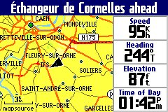
An alternative screen shows a listing of turns to come. Another screen display is the trip computer.
AUTOZOOM zooms the screen in and out automatically as you approach waypoints and turns so you always have time to make decisions. The windows on the right and details on the pop-up screen show details of the turn and distance to the turn as you approach.
Route selections for CAR or TRUCK or BUS, Motorcycle, Taxi, Delivery Vehicles, Bicycle, Pedestrian, or EMERGENCY vehicles are provided so you can be properly routed depending on your vehicle type.
CityNavigator now features about five million (USA) "points of interest". These include: Food and drink, Lodging, Attractions, Entertainment, Shopping, Services, Transportation, and Emergency and Government. In our area, there were a few restaurants we had not known about and a few prominent ones are missing. Despite some obvious updates and additions, the restaurant listing (still) appears to be about 2 years old. Listed "Attractions" include theme parks, museums, schools, parks and such. The listings were quite satisfactory though the placement of a particular restaurant or gas station might vary plus or minus a few hundred feet (once, half a mile) from the actual location. This feature could be very handy in a strange city. Do not be overly surprised at imperfections such as your favorite restaurant being missing or some restaurant that is out of business for 5 years still being in the POI list. The POIs come from a multitude of data sources and it is simply impossible to insure accuracy with the resources available for the task.
The user can give
the GPS a Street Address
or Street Intersection or select one of the, for
instance, Restaurants in the accessory map data base
module and it will LOCATE this address or location automatically
and plot it on the map screen. The Quest can then
automatically create a "turn-by-turn" route to this destination from
wherever you are. This is a very useful feature and it has worked
very well in our tests. Be prepared for a few well known items
(such as my local library) to be missing from the "attractions"
list. Still, if you are unfamiliar with an area, what
IS included will be quite useful.
Are the
Quest's 115 megabytes of MAP MEMORY enough?
Quest has a fixed
user map memory of 115megs and this is NOT expandable. We think the 115 megs will be enough for
most users-- at least for starters.
The fact that the full USA coverage
basemap can be used for navigation on interstates and major roads and
highways mitigates the need for full coverage of the high detail maps--
but... Personally we do like to have the full detail maps loaded just
in case we need services or a good restaurant while on the interstate
highway. Still, if you rarely travel more than your own
state plus four other nearby states, (on average), Quest's 115 megs of
map memory will get you there just fine. Note: The European
version of Quest has 243megs of user map memory. (I guess this
makes the European version worth the additional money Europeans have to
pay.)
When
you need complete detail for a PARTICULAR city or rural
area you are going to visit, you can load (from your laptop or
other IBM type Personal Computer) high detail maps from
CityNavigator 6 into the Quest memory using the furnished USB
cable. (MAC users note: Users report mixed results trying
to load maps using a MAC. Count on needing a PC to load maps to
avoid disappointment.)
So.. If you are going from, say, Chicago to San Francisco and back to Miami with a stop in Denver, you might load detailed maps for the four urban areas of interest and let the basemap be your guide for other areas and still have lots of empty memory in your user map cartridge for other areas. The unit automatically transitions from the basemap to the detailed maps when the detailed maps are available and back again as you move out of the detailed map areas. While it is quite easy to load new maps from a laptop computer into your Quest, having a basemap for the entire USA and Canada that will route you between towns and cities can eliminate the need to load highly detailed maps for intercity travel. That said, DO NOT expect that the basemap is as accurate as the CityNavigator maps from Navteq. There will be some areas where the map error is larger than 150ft and the Quest will think you are offroute and will claim it must recalculate. This is a minor irritation for some people but if you just ignore the problem when it (fairly rarely) occurs, things work out fine.
What are the Technical Specifications of the Quest?
Specific Questions Answered:
We do not recommend Quest for hiking or marine activities due to its reduced feature set optimized for automobile use.
The Quest used for this review includes no basemaps outside the Northern part of the Western Hemisphere. The unit has has a rudimentary political map for the world but essentially no roads are shown outside Canada, USA and Mexico and Central America. . The basemap of North America includes maps of USA interstate, national, primary and secondary state highways, cities, larger towns, waterways, rivers, and coastlines and high population parts of Canada and Mexico. (Note: See Garmin Base Maps description for more information on Base Map content.) Base Maps are included in the Quest's internal memory while USER Uploadable Street Maps on CD ROM provide street level or topo detail of user selected areas which are loaded to the 64meg to 2048meg (2GByte) CF memory cartridges. Garmin (unlike some Magellan models) provides no capabilities for the user to change from one basemap to another.
Additional
Quest features
include:
The trip computer works similarly to other late model car navigators. With Quest, you will notice that when you come to a stop, the estimated times do not go to infinity, but hold a realistic value. The GPS calculates estimated times based upon road classes in your Route and modifies the estimation by your actual speeds on the various road classes. It also computes the actual road distance between turns (waypoints) instead of using straight line distances. The results give fairly accurate estimated time to various points, even when using different road classes, like traveling on the freeway, and then exiting later on some local roads. Your estimates will not only be based upon your current highway speed, but by the combination of speeds you are using, or will be using on the various road classes. We note that the Quest was within 10 minutes on one 400 mile highway drive we made after it "learned" our driving speed habits. Usually it slightly underestimates the time principally as a result of unexpected traffic congestion which randomly occurs.
The GPS has the standard HOST mode which allows the upload/download of waypoints, routes, tracks, etc., OR use the GPS for tracking with the USB position output. The external power/data cable is different from other Garmin GPS equipment including StreetPilot models. It is doubtful that as of October 2004 any third party software is available to interconnect with Garmin's USB data port on the Quest..
The data fields, on the main display screens ARE configurable. Check the manual for details.
CityNavigator's Find-an-Address feature includes: Recent Finds, Cities, Exits, Addresses, Intersections, Points of Interest, Food, Lodging, Services, Entertainment, Attractions, Shopping, Transportation, Emergency and Government and Waypoints. However, some of the locations of restaurants, hotels, etc. are misplaced by considerable distances. Since the data is at least a year old, some businesses are "missing" but overall the data is quite accurate and useful.
When not
routing, a "Driving Status"
line on the Map display indicates such
information as "Driving South on Roswell Road near
Sandy Springs".
This can be quite useful in cities where you don't
exactly know which street you are on. Also as you are driving, the name
of each approaching side street is displayed allowing finding side
streets in the dark.
Brightness
on the Quest does NOT automatically adjust for ambient light conditions
like the SP26xx models. However, automatic changeover from night
to day mode as needed is provided.
Datums- The Quest provides the standard WGS-84 and over 100 other map datums so you can match your map display position with your accessory paper maps.
Many dozens of ICONS are available in the Quest to identify user waypoints and mark routes. Icons include airport, bank, boat ramp, car, dam, post office, and a host of others.
Street
pricing of the Quest is about US
$525 or less
and includes: Quest GPS unit, speaker/power
cable, CitySelect 6 CDROM (full USA/Canada license), Suction cup mobile
mount, USB data interface and cable, AC 12vdc
PSU and cradle for indoor use loading maps, manual, quick reference
guide and other documentation.
Features and Operation
The Quest has a
direct and easy to use
routing system. The user:
The Quest operates from external power in the range of 10 to 24 volts DC or from its internal LiOn battery. Battery life on our unit "appeared to be" about 2 hours. However, the actual battery charge lasted about 15 hours or so with little backlight use. The problem turned out to be that the "battery guage" was defective on my test unit. The Quest uses FLASH memory internally and has no memory backup battery. The LED backlit display lighting has a rated design life of 100,000 hours. The Quest shuts down when power is removed and (uniquely for Garmin handheld equipment) turns back ON when external power is restored. (Assuming the power was ON when the external power failed.)
A special Power/Speaker cable is supplied with Quest. The data/power cable used is NOT the same as any prior Garmin cable connector. You will need the (industry standard) USB DATA cable (furnished) to load maps into your Quest and/or to upload/download routes/waypoints/tracks to your PC computer. There is NO capability with the Quest for a standard RS-232 serial cable.
The external antenna connector, a MCX coax jack, is located on the right rear of the unit. The MCX jack is powered (nominal 2.7 volts no load in our unit) and has a current limit rated at 25 ma to protect the unit from shorts on the antenna cable. The normal antenna is built inside the unit and is not removable. The Garmin GA-27C (Garmin part number 010-10052-05) amplified antenna, some from Tri-M, and other 2.7 volt rated antennas work with the Quest. We believe most 3 volt antennas will work as well.
The Quest does not support NMEA-0183, DHCP or RTCM. Garmin has included its standard HOST MODE and no other option.
Operating temperature range is specified as -15C to +70C. Like other Garmin handheld GPS receivers, Quest is rated submersible to one meter per IEC529 IPX(7) with gasketed connector ports closed. The maximum altitude rating is 60,000ft and speed maximum is 999 knots.
Feature Details:
The Quest has a large number of features and displays. These include:I have tested the
Quest on roads
and highways of North Georgia and Atlanta including several
interstate trips. I have also used the Quest in Ireland, the UK,
France. Belgium, Germany and Switzerland. We used CS6 in both
the USA and Europe for our tests. Our Quest has worked properly
at all times
as far
as we could tell.. Generally,
tracking worked well but as is normal, we occasionally lost lock
momentarily in cities and in deep mountain valleys.
I have rarely had a failure to lock to SVs in my beta version Quest which was corrected by turning the unit OFF and back ON. I am confident this will be corrected in production software.
The SP performed on a par with other GPS units in every test for lock stability, multipath performance, re-lock after an underpass, and ability to suddenly change direction without loss of lock. The SP laid down smooth tracks on our highway maps during all tests. No gaps, jumps, etc. (The Quest has data smoothing like the SP-III.)
We note that all Garmin GPS models including the Quest have a form of "dead reckoning" for moments when signal dropouts occur. For instance, if the Quest is tracking along and just before a sharp turn you invert it and block its antenna, it will continue to track straight for about 30 seconds. It also provides a very good data smoothing filter to throw out random fixes that are way off track. This results in an exceptionally smooth track on a moving map display even with the "road lock" option turned off. Even with this filter, there was no overshoot apparent during quick stops, sharp turns, and similar maneuvers when normal continuous tracking was taking place.
Quest performance under tree cover and city canyon conditions was about the same as the earlier SPs, G-V, G-II+, G-12XL, and we rate that as very good.
We found the display controls easy to learn and use. The overall Quest system is quite comprehensive and suitable for car navigator use. What the average user has to work with on a day-by-day basis is very simple to understand and manipulate. The menu system and arrangement is generally quite intuitive and easy to learn to use.
Since the Quest exhibited essentially identical tracking performance with other Garmin units in our tests, we did not perform the extensive field trials we made with the G-12XL, EE, and others. For more information on tracking results with our testing of the G-12XL, and the G-II+, etc., see our reviews at: http://gpsinformation.net
Summary
Our overall impressions are that the Quest is a new generation of "miniature" and pocket sized, low cost Automobile Navigation System. While it is not the least expensive of the truly automatic self contained address-to-address car navigation systems (SP-III, iQue 3600, G-60C and some other PDA based systems may be less expensive), we consider the Quest to be "very good" in the low price class of Car Navigators. At about US$525, (Check Latest Prices Here.) we think the Quest is a great product for the money.
*Problems
and Quirks noted in using
the Quest?
1) The suction cup mount furnished with the Quest
is about its worst feature. Even after you "get the hang of it"
it is both difficult to snap it OUT of the carrier and even worse to
snap it back in. However, it is serviceable and we had no
problems
with the suction cup letting loose in 6 weeks of testing in half a
dozen vehicles.
2) As with other Garmin Car Navigators, entering street
names can be
a problem. You might know a street name as AC Lewis Road, Ac
Lewis Road, or A C Lewis Road or Baywater or Bay Water or
Baewater and the spelling may/may not match the
local convention. The user MUST spell it like the
Garmin/Navteq
database or the address cannot be found. This can lead to not
being able to find a street that you know is there. Navteq
tells us that their convention is to run
initials together and use caps, so you might try that if you get
stumped with a street name with initials. For a street address
with a highway number, try just the number such as 32 (not HWY32).
3)
POIs are often in listed in "groups". There may be several groups
of
restaurants by the same name (different franchises I am guessing) and
you do not readily know in which group the closest
store can be found.
4) POI
groups are incomplete (though they are VERY VERY helpful).
As examples: I find that
some post offices and libraries in my local area are not included, but
MOST are. In
Zurich, the Transit Information sent me to the Hertz repair garage
instead of the car return office. (If they could just sort out
so that I could easily find the nearest Dairy Queen I would quit
fussing!)
5)
On occasion, we see the router
generate "funny routes" such as taking a busy numbered federal highway
instead of a nearby freeway.
Overall, the Quest performs
as well as other Car Navigators we have used. Navteq
tells me that these problems WILL be looked at if users will go to http://update.Navtech.com
and fill out the report form. Lets ALL do
it! Overall, I must say that every edition is
better than the one before as to routing problems.
6)
During Installation, you MUST install the MapSource software in your
computer BEFORE you
plug in your GPS or things will not go smoothly. It is also
necessary to handle each disk more than once during installation.
7) On rare occasion, on the internal antenna and sitting on the
dash, Quest would lose lock for an extended period (such as a
tunnel) and when we came out, we would lock to one or two SVs and
then the unit would not acquire further SVs. Turning the unit off
and back on restored lock almost instantly. Likely this is a
firmware bug which will be fixed in a future update.
8) Currently, the "battery remaining" indicator indicates incorrectly
in A FEW units. See Details HERE.
Which GPS do I like to use now when I go on automobile trips? The StreetPilot 2610/2620. I must add that the Quest is a great unit when small size and lower cost are part of the equation. It seems ideal for a portable unit for a traveler.. That said, I do think more memory than the 115megs provided would be a distinct advantage. I really have no problems with the functionality of the Quest or its performance in almost 5000 miles of driving during the six weeks of evaluation.
If anyone has any additions, questions, suggestions, error corrections other comments, please feel free to Email.
Notes: (*) Freshly changed
items.